
|
|
|
|
|
 |
|
|

 G e o r g i a O u t d o o r s . C o m |
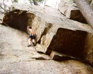 Pigeon Mountain Pigeon Mountain is usually referred to as either Rocktown or Lost Wall, the two most popular climbing spots on the mountain. Here, on the southernmost vestiges of the Cumberland Plateau, an area of large boulders has been exposed on the top of the broad ridge. Rocktown is the area of large boulders atop the ridge. The Lost Wall is an exposed band of rock along the eastern side of the mountain. Location: Pigeon Mountain is located in the extreme Northwest Georgia, about 1/2 way between Atlanta, GA, and Chattanooga, TN nearest to the town of Lafayette, Georgia. Pigeon Mountain is actually a spur jutting northeast off 50 mile long Lookout Mountain. It lies between two popular Lookout Mountain climbing sites, Sunset Rock in Tennessee, and Sandrock, in Alabama and shares characteristics of both areas. Driving directions (from points to the south) Take I-75 until north of Atlanta. About 1/2 way between Atlanta and Chattanooga watch for I-75 exit for Resacca, Lafayette, (HWY 136) - Turn L onto HWY 136 & cross over I-75. Go 6.5 miles to T intersection turn Right to stay on HWY 136. Go 14.3 miles (through Villanow & over mountain) to T intersection & turn Left to stay on HWY 136. Go 1.3 miles and turn Right to stay on HWY 136. (be careful this intersection will sneak up on you). Go 3.9 miles to HWY 27/136 (traffic light) - continue straight ahead to HWY 27 in the town of Lafayette, Georgia. Turn Left onto HWY 27/193 and go a short distance. HWY 193 north will turn Right. Go 2.7 miles on HWY 193 to Chamberlain Road and turn Left onto Chamberlain (Fina station on Right) Go 3.3 miles on Chamberlain Rd to Crockford-Pigeon Wildlife Area sign on Right - turn Right onto gravel road. Take this road approximately. 1.8 miles (as the road steepens it gets rougher, and goes up the Mt. via a series of switchbacks) Lost Wall Parking is just past the fourth switchback on the Left. Continue to ROCKTOWN: Continue past the Lost Wall pullout up the Mt. The road improves again once it levels off near the top of the mountain. When the road splits, take the Right fork (Rocky Road ) 1.3 miles further. Turn Left onto Rocktown Road (sign) dirt road 1/3 mile to parking area. Trailhead is @ the right corner of the parking lot, next to the information kiosk. Camping is allowed in woods surrounding parking area. There is a flat trail leading 1 mile to the climbing area. If coming from the north (i.e. Trenton, GA or Chattanooga, TN), You can come across lookout mountain on 136. When you intersect 193, take it to the right. You will come to the Fina station at the right turn onto Chamberlain Rd after 10 minutes or so. This eliminates driving into and out of Lafayette, GA. Description Pigeon Mountain can be divided into two main climbing areas - Rocktown and the Lost Wall. Rocktown: Rocktown shares the characteristics of Sandrock, Alabama. It is located on top of the flat mountain, and is comprised of several acres of large sandstone boulders, averaging 30 - 40 feet high. The rock is unusually juggy, with tons of hand and foot holds, and some very unique formations. It is here that some of the best bouldering can be found. The very featured rock, long low roofs, and shear variety provide scores of challenges, Unlike Sandrock, this area remains in essentially pristine condition, unpolluted by the trash and graffiti of it's Alabama cousin. This is most likely due to the easy 1 mile hike in from the trailhead. Lost Wall: Lost Wall is more characteristic of Chattanooga, Tennessee. Here, a band of cliffs is exposed, about 1/2 way up the mountainside. This long band runs to the southwest for a good distance ranging to about 60 feet in height on average. One reason for Lost Wall's popularity is the close access to the road. You can hike in on an easy trail and be at the first climbable section of rock in a couple of minutes. The vertical slab here hosts Steggo 5.6 to the left of center, though the entire face offers good climbing at low-moderate grades, and is easily rigged with top-ropes by scrambling up the left side of the rock. This ease of access makes it a prime location for groups looking for a quick setup on Sunday mornings. Parking at the trailhead is limited to about 4 cars, but the rest just pull off along the road. There is more climbing available down the cliff line, though some of it must be trad led first to rig top-ropes as access to the top of the rock is limited. Gear Standard top-rope gear, 50 m rope is plenty long, routes are short. No nuts, cams, chocks needed to rig top-ropes at Rocktown. With long slings or a piece of static line, you can rig almost any top-rope. Leave the gear home unless you're looking to lead routes at the Lost Wall. There are no bolts here, routes are too short to bother. If you're bouldering, a good crash pad is advised. There are some excellent overhung routes. Miscellaneous Pigeon Mountain is located in the Crockford-Pigeon Wildlife Management area. There is no camping in Rocktown, but you may camp at the trailhead. Fires are not permitted within the climbing area. There are numerous other primitive campsites located on the mountain, you'll see some as you drive in. This area see a surprising amount of visitation on the weekends by climbers as well as tourists. <% ' All ads are set in the adverts.txt file in the "ads" folder. Set MyAd=Server.CreateObject("MSWC.AdRotator") %> <%= MyAd.GetAdvertisement("../ads/adverts.txt") %> Main
Page | Camping | Fishing |